

- An area in the northwestern Caribbean Sea is being closely monitored.
- A tropical storm is likely to develop in the coming days.
- A hurricane is likely to develop in the Gulf of Mexico by Wednesday.
- Most forecast models suggest the hurricane will make landfall in Florida or the northern Gulf Coast on Thursday.
- The hurricane could be strong when it makes landfall.
- Impacts could persist in parts of the South through Friday.
Tropical Storm Helene is expected to form in the western Caribbean Sea and could intensify into a powerful hurricane before hitting Florida or the northern Gulf Coast later this week.
Those along the U.S. Gulf Coast from Louisiana to Florida should monitor this situation closely, stay informed of changing forecasts in the coming days, and prepare their hurricane contingency plans.
Where he is currently: A large area of low pressure is located in the western Caribbean Sea. Thunderstorms are gradually becoming more organized in this area.
It has been named Invest 97L, a convention used by the National Hurricane Center to identify features it monitors for future development.
The NHC also scheduled its first Hurricane Hunter mission in the western Caribbean Sea for this afternoon.
(Improve your forecast even further with our detailed, hour-by-hour analysis for the next 8 days – available only on our Premium Pro Experience.)

Here’s when a storm might form and where it might move:
- Monday-Tuesday:The latest computer forecast models suggest that a depression or tropical storm could form as early as Monday or Tuesday. By Tuesday, Helene could develop near Cancun, Cozumel and western Cuba as a tropical storm or even a Category 1 hurricane. Locally heavy rain and strong winds are possible in these areas.
- Wednesday:Helene could have lingering impacts in Cancun, Cozumel, and western Cuba, especially early on. We then expect Helene to enter the southern Gulf of Mexico, most likely as a hurricane. Strong surf and outlying rainbands could reach parts of the Florida Gulf Coast from the Keys to the Panhandle.
- THURSDAY:While the forecast remains uncertain, we expect Helene to make landfall as a hurricane, possibly a powerful one, sometime Thursday. While computer forecast models suggest the most likely location for a hurricane is between Florida’s Big Bend and the Panhandle, keep in mind that hurricane impacts (surge, winds, rain) often occur far from the center. There are still a few computer ensemble model forecasts with tracks as far east as the west coast of Florida and as far west as southeast Louisiana. So anyone living along the northern Gulf Coast from Louisiana to Florida should continue to monitor these forecasts for any potential changes in the future.
- Friday:This system is likely to continue inland with lighter winds, but local torrential rain over parts of the Southeast.

Model prediction tracks
(The lines on this graph represent several of the many trajectory predictions from various computer models. This is not an official forecast, but is used as a guide to create the projected path.)
How strong could it become: Helen could become a fearsomely powerful hurricane in the Gulf.
That’s because heat content is a favorable ingredient for intensification, and the map below shows that there’s plenty of deep, warm water in the northwestern Caribbean and parts of the Gulf of Mexico. In fact, the heat content of the Gulf of Mexico is at record levels for this time of year, according to University of Miami tropical scientist Brian McNoldy.
(For even more accurate weather tracking in your area, check out our detailed 15-minute forecast in our Premium Pro Experience.)

But it’s not just hot water.
Some forecast models suggest that upper-level winds may disperse over Helene, which is favorable for strengthening, rather than shearing and tilting Helene’s circulation.
For these reasons, Hélène could reach Category 3 intensity in the eastern Gulf of Mexico before making landfall.

Rainfall potential: While it is too early to know details of other impacts – including storm surge and winds – we expect Helene to produce heavy rainfall generally along and to the east of its track.
The heaviest rains are expected Thursday through Friday in parts of the Southeast, but some bands of heavy rain could arrive as early as Wednesday. These rains could cause flash flooding, particularly when combined with storm surges and over higher ground.
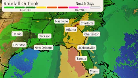
Precipitation forecast
(Although not all of the rainfall shown above is from this tropical system, this should be interpreted as a general overview of where the heaviest rain may fall. Heavier amounts may occur where bands or clusters of thunderstorms stall for a period of a few hours.)
Jonathan Erdman is a senior meteorologist at weather.com and has been covering national and international weather since 1996. Extreme and bizarre weather are his favorite topics. Contact him at X (formerly Twitter), Son, Facebook And Blue sky.


